从太空绘制的南极洲地下复杂的中尺度景观
近日,英国爱丁堡大学Robert G. Bingham团队研究了从太空绘制的南极洲地下复杂的中尺度景观。该项研究成果发表在2026年1月15日出版的《科学》杂志上。
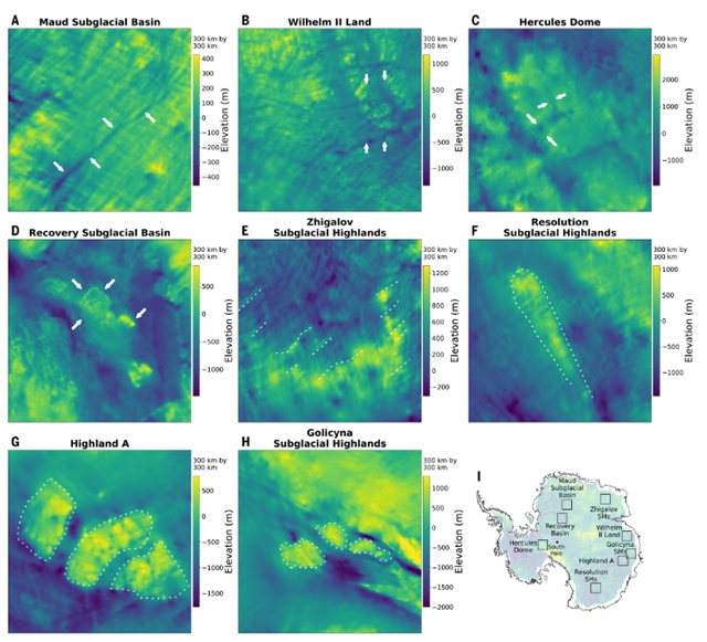
南极冰盖所掩覆的地形地貌为理解其历史演变提供了关键线索,并深刻影响着冰盖对气候强迫的响应机制。然而,研究组对这一关键界面的认知长期依赖于不规则分布的地球物理勘探数据之间的插值推算,导致南极冰下地形图存在显著的空间偏差。
由于冰流在基岩障碍物上产生的应力变化会塑造出对应的冰面地形特征,近年来获取的高分辨率冰面卫星地图为绘制冰下地形提供了具有变革意义的基础。研究组通过应用冰流物理学原理分析冰面高程图,并结合地球物理冰厚观测数据,绘制了南极洲冰下地形的大陆尺度高程图。该成果深化了对中尺度(2至30公里)冰下地形结构的认识,并揭示了冰下粗糙度与地貌特征的空间分布规律。
附:英文原文
Title: Complex mesoscale landscapes beneath Antarctica mapped from space
Author: Helen Ockenden, Robert G. Bingham, Daniel Goldberg, Andrew Curtis, Mathieu Morlighem
Issue&Volume: 2026-01-15
Abstract: The landscape shrouded by the Antarctic Ice Sheet provides important insights into its history and influences the ice response to climate forcing. However, knowledge of this critical boundary has depended on interpolation between irregularly distributed geophysical surveys, creating major spatial biases in maps of Antarctica’s subglacial landscape. As stress changes associated with ice flow over bedrock obstacles produce ice surface topography, recently acquired, high-resolution satellite maps of the ice surface offer a transformative basis for mapping subglacial landforms. We present a continental-scale elevation map of Antarctica’s subglacial topography produced by applying the physics of ice flow to ice surface maps and incorporating geophysical ice thickness observations. Our results enrich understanding of mesoscale (2 to 30 kilometers) subglacial landforms and unmask the spatial distribution of subglacial roughness and geomorphology.
DOI: ady2532
Source: https://www.science.org/doi/10.1126/science.ady2532